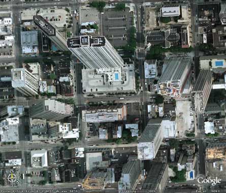
Check this out! I was messing around with Google Earth today, and came across a strange MC Escher like image. The image below is from from Chicago, USA. You can see it on Google Local. Why do the buildings seem to be leaning in different directions? Really doesn’t make sense to me. Anyone has his own theory? Previously: “Lego Escher” , “Staircase”, “Peruvian Jesus”, “Flying Car”.
I think that’s the point at which they splice the different patches of photos together. They look like different angles because they are.
Doh, sorry for the double post.
in addition, you can see a line at the top of the road where it changes.
I think they just grabbed images and mashed them together. Apparently, nobody checked if the buildings were all leaning in the same direction. :p
I believe they appear to be facing different directions because the image shown is actually a photo stitch. The satellite(s) that take thousands of pictures and they are pieced together by computers on earth. If the satellite is to the left of a building, the building will look like its leaning to the right and vice versa…likewise…if the satellite is directly above a building it will not appear to lean to any side.
Photos are taken by a moving sattelite; they are also teselated from many different images from different sources and times, so the positions are different.
It is just the angle of the individual shots. If you look at it from the perspective that this is one photograph taken with one lens then it makes no sense — but this is actually a composit of many images that were taken from slightly different angles — none of which are taken from a perfect zenith.
Not all pictures in the google local/earth are from satelites, I woujld guess that those pictures are from aerial photogrphy. if you follow the orientation of the buildings you will notice that their direction changes slowly from one orientation to the other and then suddenly they snap to the other orientation.
This behaviou makes me think that they were shot by an helicopter that sweeped the citty taking several pictures. The buildings rigth beloow the hellycopter while the picture is taken are viewed from the top they one arround have diferent orientation. The point where you stich two images get weird.
Not only visible at Google Earth, but also at Google Maps and mashups based on its API. In Tagzania we have a good collection of these Escher effect locations, and that one in Chicago is also viewable there.
i.e. the Eiffel Tower does some kind of weird curl-thing.
panoramic photo then stitching
YEA I GUESS THATS PRETTY COOL.
The buildings look like they are leaning different directions because they literally are. Wind can actually bend the buildings if they are tall enough. If you’ve ever been at the skydome and look straight up at the CN Tower it looks like it’s swaying. It is.
yea, thats gotta be a point where four images are connected, this happens because opne image is taken, then the satellite moves and another is taken from a diff angle
i think its cuz the camera’s in a certain angle
They probabably are leaning different directions. tall buildings like that do tend to tilt a little, and because it was so high up and the buildings are so tall compared to other ones around it, it makes it look more drastic than it is. Now who agrees with me??
I don’t care, but it’s making me sick looking at it! Lol
saster i agree w/ u, y is every1 so lazy, i think its gr8 that u r standing up 4 wat u blieve in
sry saster i dont no wat u r talking about, wen does ne1 ever use abb. 4 words?
ill brb
hahaha Saster you just made me laugh out loude. I mean loud. It is so true.
ur rite saster, y is every1 so lazy? lets all vow not 2 use abb. words nemore. r u w/ me?
Yo I think it’s real the roads match up and evrything
i tried to find this on google earth instead of google local and i found the place, but the building or basically viewed straight from the top and they dont look like they are leaning in different ways
lol all pictures are taken by satellites, but sattelites are not above all areas of Earth, they follow a distinct path. Some sattelites have cameras to picture places on earth. For some places the cameras cannot zoom to positions where you cannot see closer than others.
And by the way this is normal because photos were not taken in one day but in months and probably i noticed they were taken 2 years ago cause i noticed some changes in landscapes or some building from my country that happened 2 years ago and google earth didn’t have them.
Anyway its only the positions of the satellites that cause this think to happen.
They are different photos taken at different angles
Of course it was photographied in two photos whith the cameras looking in diferent directions.
And I an 11 years old, come on!
hee hee
cool
=^.^=
ok. i love skechup
Google Earth images are NOT all taken by satellite. A quick glance at the Google Earth FAQ can tell you that.
http://earth.google.com/faq.html
it is that the pic is taken as a 2d image and not a 3d image and you are to the side of google earth and it make it look as tho they are lening
check out this pic. I found it just a little down from the first one. you can see the hancock tower in this one.
Chicago
There is a better one: open Google Earth and zoom in on the Empire State Building in the middle of Manhattan.
That’s just the remnents of the great May 26, 1909 Chicago Earthquake… :)
Now i know where it is like that:
Activate 3D-Buildings and the look at the same spot, it’s looking normal from that view.
its cuz when they take the satelite images. they just take a bunch of different images at different times and things like that and apperently from slightly different angles and put it all together. =D
It is obvious that it’s because of the earths shape. Everyone knows the earths round!
makes me dizzy
It is called a ‘mozaic’. Several (or many)pictures are spliced together or overlayed over each other, so as to appear to be a single picture. The pictures that you see from the’Hubble Space Telescope” all use Mosaics to form their pictures.
Okay, I think they’re real. I’ve seen something like this when the buildings are leaning. In Montreal, Canada you’d see the building that looks like its falling. These look like the same thing
you’re all wrong!!!
those buildings are really leaning in different directions.
that is the ONLY explanation. :P
If you look at the link they have fixed it
Aitana, just because your 11 doesn’t mean you’re better than everyone else. I’m 13, but I prefer people to treat me as an adult, which is why I don’t usually tell people that I’m only 13. Saying that you’re only 11 is just going to make people treat you like a kid. I’m glad that you figured it out, but you don’t need to make everybody else feel bad because someone younger than them got it and they didn’t.
To everyone else, I know it really doesn’t make much of a difference in this case, but the Sears Tower actually leans 6 degrees (I think it tilts to the west).
P. S. Though I occasionally will do it myself, I usually hate it when people use abbreviations for words, especially (sp?) when the words are only three or four letters long and are not real acronyms (like SCUBA for self-contained underwater breathing apparatis. Who has time to type all that?).
the lense on the camera is convex thus bending the image in two directions….
That isn’t a real city, that is like a circuit or something. I’ve seen it before. Something inside something electrical. It’s not buildings.
holy shit that is totaly outa wack
i want tat as a poster lmao
WOT THE HECK?
Wow, i so want to live there. In an M.C Esher world that makes no sense, would be awesome, and i’d let you live there as well Vurdlak!
But back to the illusion, i think it’s a photo stitch. The photos were probably taken from a plane, or something similar. Not all of the images like these are taken from satelites.
Actually, this looks like the inside of a computer
I think those are multiple pics and are taken at difrent days , the position of the earth was difrent.
I see five or six different angles: cool to study Google earth.
this does not always work but sometimes it does, the process of elimination:that is the process of figuring out what something is by figuring out what it isn’t; some crimes are solved this way by the police. first off this effect is not caused by the curvature of the earth because while the curvature of the earth is certainly there it is so minute as to be unnoticeable except from great distances; the closes is from five miles off, that is how far a boat has to travel on the sea to disappear from the horizon. it may be caused by the wind or pictures taken at different time of the day and spliced together as i cannot eliminate these, it may partly be caused by the towers tilting some, but i do not think that they lean enough to cause this much difference to be noticed. i think it is the inside of a computer because that is what it looks like now that it has been mentioned; use the internet explorer web browser and blow up the image 400 times and see.yes i know that i am not the person that solved this but the process of elimination does work some times
haha Aitana im 11 too…..I think its photo shopped >.<
This isn’t hard to explain. These images are taken by satellite.
Multiple passes by satellite. 1st pass takes a photo of an area from northwest (for example); 2nd pass takes a photo of an adjoining area from southwest (for example). Google stitches the two photos together and you have this “illusion.”
It’s the so called ‘Escher Effect’ on Google Earth…
Paul Has It Right The Images Taken In Three Different Pass From A Different Orientation And Then Stitched Together Creating This Strange Effect
Why Would You Type Every Word With Capital First Letters?
i think the google satelite camera shot two pictures from diffrent angles and joined the pictures together on a computer.
this photograph is taken in a MIRROR shoot mirror is top towards camera
I would have to say they only appear to slant maybe because the photo was taken on an angle to the right, as if it wasn’t looking square on down towards the buildings.
Um, I’m just guessing here, but maybe it is the angle of the camera.
3 point perspective.
easy… we are inside a dream inside a dream inside a dream inside a dream
There’s these little birds called satellites they are always watching. When they blink they take pictures and email them to Google for stitching. Since earth is round and the images flat somethings gotta give.